Roanoke.com states: “In Virginia, McAfee Knob is the Appalachian Trail's poster and postcard image. Pick up an Appalachian Trail calendar and there's a good chance it's there.” The knob has impressive views of the Catawba Valley and Tinker Cliffs. It is arguably the most photographed location on the entire Appalachian Trail.
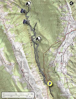
Here is a map from hikingupward.com. They have a good summary of this hike here: http://www.hikingupward.com/JNF/McAfeeKnob/
After spending the night in a hotel in Roanoke, we headed to the trailhead on VA 311. We made sure we had some warm clothes, water, and snacks.
Andrew and Dad at the trailhead

Where we started the trail

The trail was mainly in the woods and icy at times.


The trail was easy to follow and we quickly made it John's Spring Shelter. There was a tent filled with miscellaneous gear but no people around.


Some of the trees were covered in beautiful ice.

As we neared McAfee Knob, we began to glimpse our first big views of Catabwa Valley.

We soon were at the top and had to share it with only one other hiker, a nice guy who lived nearby. He told us about Tinker Cliffs and how we could walk the entire ridge seen in the picture below.

The views were spectacular as the sun's light was shining through the dark clouds on the valley below.


View McAfee Knob from the other side
Then it was time to return to the trailhead. We decided to return with the same route, however, there is an option to hike on an old fire road that may be easier. By the time we were back at the trailhead it was dark.

This was a spectacular day hike and certainly worth a re-visit. Hopefully next time I'll be backpacking from Georgia to Maine!
No comments:
Post a Comment