~39 unique NCT miles
~42 miles biking
~ 6 miles off-trail
Of all the national scenic trails, I have currently hiked the most miles on the North Country Trail, a 4600 mile
trail from North Dakota to New York (soon Vermont). Whether it be beautiful segments in the Boundary Waters Canoe Area Wilderness (Border Route Trail, Kekekabic Trail), along Lake Superior's beautiful shoreline (Superior Hiking Trail, Pictured Rocks National Lakeshore), or in Michigan's Lower Peninsula (Manistee River, Jordan River Pathway), the NCT has provided exceptional backpacking opportunities.
In the summer of 2016 I have returned to Northern Lower Michigan and have had the opportunity to complete much of the established NCT in the eastern upper peninsula. This section includes remote country in the Hiawatha National Forest and along the beautiful shore of Lake Superior. I have also been able to arrange for 3-day weekends at work and plan to use my bike more frequently vs. backtracking on the NCT as I have previously done.
During the weekend of May 20-23, 2016, I was able to complete a fantastic hike on the NCT between the Tahquamenon River and Trout Brook Pond. It took some careful planning to coordinate preferred campsites, biking options, and also an off-trail route.
After driving up from the lower peninsula, I started at the parking at the Naomikong Overlook on the scenic Lake Superior Shoreline Road Friday evening after I dropped my bike off at Trout Brook Pond. I then hiked southbound .3 miles and stayed at the Naomikong shelter. The next day I hiked a long day on the NCT southbound to Trout Brook Pond where I had turned around the previous weekend. On Sunday I biked back to Lake Superior on forest service roads (mainly Dick Road). I followed the scenic Lake Superior Shoreline Road past the Naomikong Overlook to M-123. I biked north on M-123 to Lone Pine Road and followed it back to where it came to Lake Superior. I stashed my bike and hiked off-trail north to the mouth of the Tahquamenon River. From there I turned around and continued off-trail south with a campsite on the beach before connecting with the NCT at Bark Dock. I followed the NCT back to Naomikong Overlook.
See the map below:
I arrived at the Naomikong Overlook with a great view as the sun was beginning to set.
Naomikong Overlook

I partly wished that I had hiked north from Trout Brook Pond to get this first view of Lake Superior on the NCT, but planning camping was challenging (in that I wanted to camp at two specific places: the Naomikong Shelter and Trout Brook Pond). I most likely wouldn't have seen this pleasant view of the sunset either.

Trailhead sign at Naomikong Overlook

Within a few minutes I was at the shelter.


It was at an old campground on Naomikong Pond. The moon was quite large.

The Hiawatha Shore-to-Shore chapter of the NCTA had informed me about the shelter. Boy scouts had put a lot of work constructing it.


There were a few bugs starting to come out as I went to sleep, but they didn't bother me much as I slept that night. A bird had a nest in the shelter and I heard it flying in the night. I awoke early in the morning and enjoyed the view. I signed the trail register in the shelter and read a report from "Attrition", a thru hiker (extreme one at that) who had previously stayed at the shelter a few weeks before.


Soon I started the hike southbound to Trout Brook Pond. It was a fairly long day, somewhere around 30 miles.


There were some colorful early morning views of Naomikong Pond.

I could see the shelter through the trees on the other side of the pond.

Then I entered the forest and hiked a nice section of boardwalk.


This hike went through several managed forest areas on my way to Trout Brook Pond.

Water sources were somewhat limited and it was quite dry.


There were nice flowers on the trees.

The trail went beside a scenic pond.


As I approached M-28 there was a large open area.

The lone tree remaining had a blue blaze on it.

M-28

Even though there was evidence of significant logging activity, the trail in this area was well marked.

I came to the spur trail to Soldier Lake. I decided to go to the lake and get some water.

The spur trail to Soldier Lake follows a two-track.

At Soldier Lake I stopped at the day-use area for a break.
Soldier Lake

Then I hiked off-trail to connect back with the NCT.


I entered the forest again.


I came to the north crossing of Dick Road.


Next I came to some excellent views of Betchler Lakes.


After leaving Betchler Lakes, the trail went back to the forest.


The trail came near the headwaters of the Pine River and I walked down the bank to get some water.

The trail stayed close to the river with occasional views.

I crossed W Lone Pine Road.


Then I came to S Dick Road and it was less than 10 miles to Trout Brook Pond.


There was some great recent trail work.


I made it to the Pine River Bridge.

I could hear some people talking nearby.

I went by the campground and there were a group of boy scouts nearby.

The trail was near a forest service road in some places.


Then it turned east and went past some impressive tree stumps.

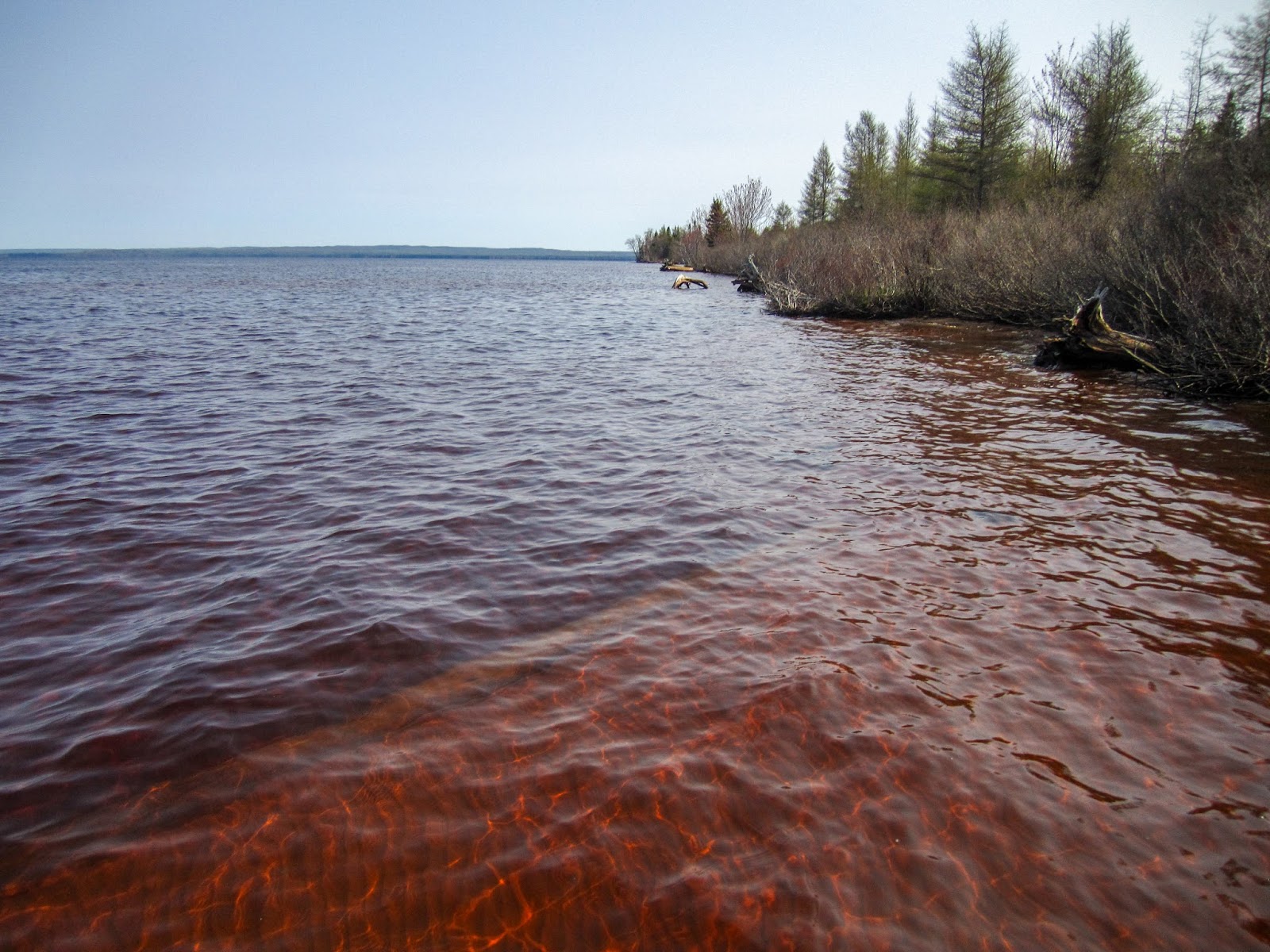
I came to a view of Biscuit Creek.

I crossed over the creek on the road and started the final section to Trout Brook Pond. It started to rain lightly.

I dropped off trail to get a nice view of Biscuit Creek.

The trail went through some logging areas, but they had many impressive boardwalks.


The boardwalks were built by Americorp Cedar G. in 2012.


The trail crossed some train tracks.

Then I arrived Trout Brook Pond.

I looked for a place to set up camp.

I followed a spur trail down the dam at the outlet.


I continued to follow the spur trail to a parking area on the Northeast side of the pond. There was a nice view of the dam.

I decided to return to the dam and set-up camp nearby. While I was setting up my tent, I was startled by a fisherman out for the evening, the first person I had seen near the trail all day. There were some mosquitoes flying around, but they didn't bite much.

As I was getting water from the outlet, I discovered I had ~10 ticks on me. I took a picture of one for identification later. It appears to have been a wood tick.

Campsite on dam with outlet visible to right.

Panorama of Trout Brook Pond

There was a nice evening view of Trout Brook Pond from my campsite.

As I was trying to sleep, I heard a noise under my tent. I turned my headlamp on and discovered a large toad under my tent's mesh floor. It didn't seem to want to leave so I went back to sleep.

There was a nice early morning view of Trout Brook Pond with the moon.

There was a great reflection of Trout Brook Pond.


I began my short hike to my bike near H-40. I went past a possible campsite near the spur trail.


Soon I was back at my bike and I studied my map for the ride back to Lake Superior. The bike ride back would generally parallel the NCT on forest service roads.

I started biking west on H-40. A car going the other direction pulled up and lowered its window, stopping in the middle of the road. A woman was looking for the Pine River Campground, as she needed to pick up her son who was camping with the boy scouts. I showed her my map and directed her in the right direction.
I took S Hayward School Road and passed the NCT where it crosses Biscuit Creek.

Then I turned left onto Pine River Road and followed it to the Pine River Campground. I stopped to get some water.


I continued to Dick Road and then turned north. The road crossed the Pine River.

I continued north on Dick Road to the NCT's north crossing where I took a break.


I continued north and stopped to take a picture of a map.

I came to M-28 and turned east and followed it to S Flat Foot Road, which in some places was quite sandy and required walking my bike. I was surprised to see ~7 fancy sports cars come up behind me. I came to the paved S Salt Point Road and it was a pleasant ride to Lake Superior. On the way I crossed the NCT.

Lake Superior from S Salt Point Road

There was beach access across W Lakeshore Drive and I stopped to take a break.


From there it was a short ride over to the Naomikong Overlook.


I didn't stop for long and continued biking on the scenic highway. I stopped at the Shallows Day-use area. I could see the NCT through the trees and at times when it came out to the road.

Then I came to a portion of NCT that I wasn't sure if I would hike.

I continued biking out to M-123.

I followed M-123 to Tahquamenon Falls State Park.

Then turned right onto Lone Pine Road and followed it to Lake Superior access. From here I dropped my bike and went off-trail to the mouth of the Tahquamenon River. Please use caution if attempting this route and check the weather forecast. Lake Superior can be quite unpredictable and dangerous.

It was a scenic hike, but I can see why the trail is not located here. It's very swampy and thick with vegetation.


It was slow going and I eventually just started walking in Lake Superior which was quite shallow and surprisingly warm.


The lake was also very sandy in this area.

I went past a small island and wondered if it would be possible to walk to it.


It was rare to have a sandy beach to walk on.


I came to my first view of the bridge over the Tahquamenon River.

Soon I was at a day-use area and I took a break to decide what to do next.

I wanted to hike the NCT between Bark Dock and Naomikong Overlook. I could road-walk back on M-123 or turn around and continue south along the shoreline. Somewhere along the way I needed to find a place to camp.

I decided to return along Lake Superior.

I decided it was the fastest and most scenic to just walk in the lake.


Soon I was back at the island.


I passed where I had dropped my bike off.

I passed several creeks without difficulty.

I could still see the island in the distance.


another creek

There weren't many opportunities for camping. Even the nice grassy areas were still swampy.


I looked at aerial images on my phone and identified a potential beach that I would be coming to in a few miles. I passed several camping opportunities but decided to wade onward.

The forest was quite thick in places.

I arrived at the beach and began looking for a place to camp.

I passed another creek.


Near the southern end of the beach a found a nice spot, somewhat elevated from the shoreline. I could see all the way over to windmills in Canada.

I walked out into Lake Superior to take a panorama of my campsite on the beach.

Panorama of Lake Superior

It was a great, remote place to camp.

I awoke to a colorful morning sky.

Then there was an impressive sunrise over Lake Superior through the mesh in my tent.


I walked out to get some water and took a picture of my campsite on the beach.

I packed up camp and began my hike to rejoin the NCT.

The lake in this section was rocky, but the water remained shallow.

I went past a small sandy cove.

Looking back to the beach I camped on

I could still see all the way out to the point where that small island was the day before.


As I neared Bark Dock, I came to another sandy beach.


There was a small boat at Bark Dock.

I joined the NCT. In this section it stays in the forest between the beach and the scenic highway.

There were still nice views of Lake Superior.


The trail went out to the road to avoid stream crossings.


I went out to the beach for a picture. Near the highway, camping isn't allowed between the road and the lake.


There was a great view where a creek entered the lake.


In some places the trail is out in the open just above the beach.


I heard a lot swhooshing noise overhead and looked up to see a bald eagle flying away.


I took a break at the Shallows Day-use area.

From there, the trail was expertly made and quite wide.

I went over a boardwalk.


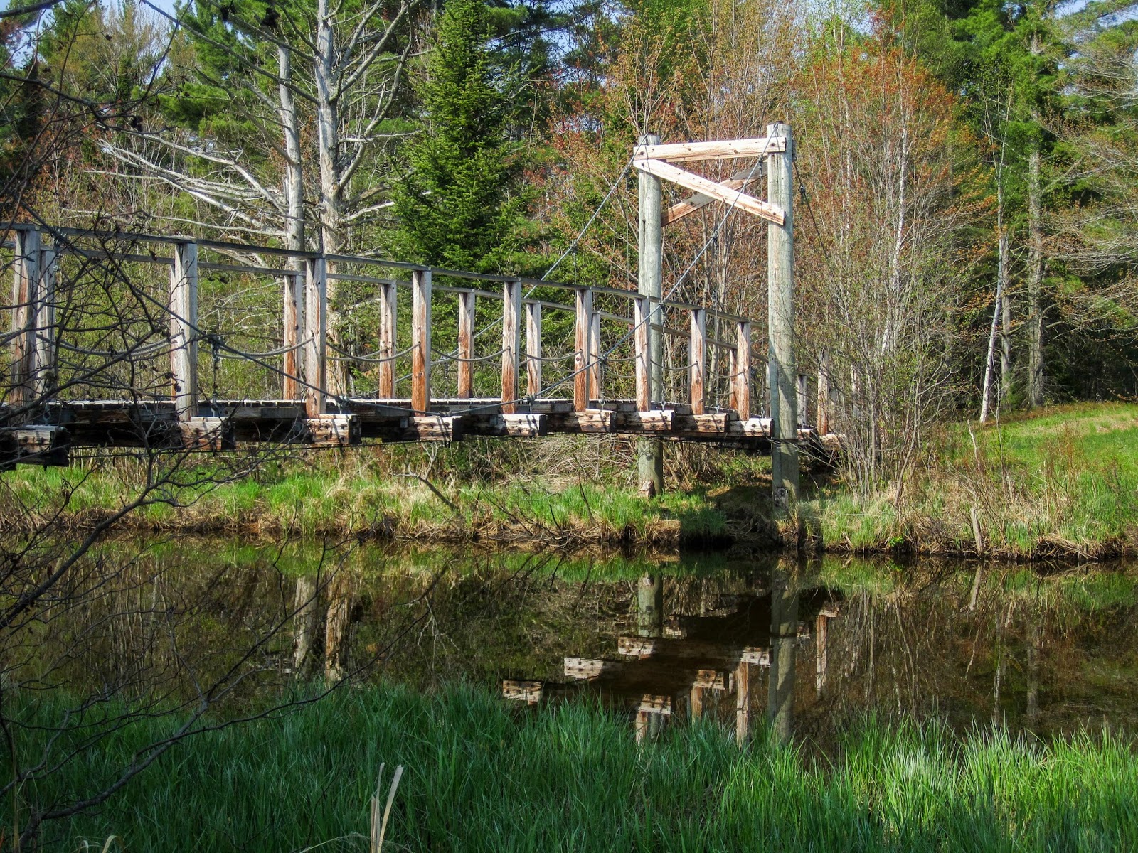
I reached the impressive suspension bridge over Naomikong Creek.

Naomikong Creek


I went out to Lake Superior for one last view from the beach.


Then there was some nice boardwalk on the way up to Naomikong Overlook.


The final portion had great trail built into the hill.


Naomikong Overlook

I drove back to Lone Pine Road to get my bike.

I enjoyed one last view of Lake Superior and then began my return journey to lower Michigan.

This was another great hike on the NCT with a variety of scenery. Even though I didn't hike all the NCT through this section, I have completed a continuous footpath/lake walk to the Tahquamenon River where I hope to continue on the NCT in the future. Thanks to the NCTA for routing and maintaining this scenic section of trail.